
Water Storage Failure And Short-Lived Koh Ker Capital Of Khmer Empire
Conny Waters - AncientPages.com - In ancient times, Koh Ker was an important city of the Khmer Empire of South East Asia that lasted from 802 CE to 1431 CE. However, it lived a very short time as the Empire's capital.
Koh Ker is the modern name for an important city of the Khmer empire. For a brief period of time, during the reigns of kings, Jayavarman IV and Harshavarman II, the ancient city of Koh Ker became the capital of the whole empire (928–944 AD).
 In ancient times, Koh Ker was an important city of the Khmer empire of South East Asia that lasted from 802 CE to 1431 CE.
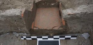
The largest water management feature in Khmer history was constructed in the 10th century to store water but the system failed already in its first year of operation. This event possibly caused the return of the capital to Angkor.
Now, a research team led by Dr. Ian Moffat from Flinders University in Australia used ground-penetrating radar to map the surface of a buried spillway in Koh Ker to shed more light on the reservoir failure during its first year of use.
See also:
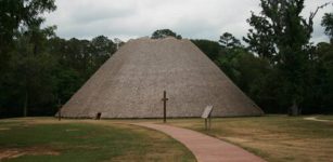
Forgotten And Overgrown Step Pyramid Of Koh Ker – Ancient Memory Of The Khmer Empire
Ancient City Of Koh Ker Was Occupied Much Longer Than Previously Thought
The study shows that the 7km long embankment was designed to capture water from the Stung Rongea river but modeling indicates it was inadequate to contain the average water flow in the catchment, putting into question the legitimacy of Khmer kings, and forcing them to re-establish their capital in Angkor.

Regional map of Koh Ker. The detailed map area (top right) is shown as a white dashed box on the regional map (left). The black dashed line in the detailed map area shows the approximate area of Fig 2. The location of Koh Ker compared with Angkor, Phnom Penh, and Ho Chi Minh City is shown in the bottom right. North is up in all figures. Image credit: Dr. Ian Moffat, Flinders University
"At that time, embarking on projects of civil engineering such as temple building, urban renewal, and the development of water infrastructure was central to establishing the legitimacy of Khmer kings," says Dr. Moffat.
"It's not difficult to envisage that the failure of the embankment at Koh Ker--the largest and most ambitious infrastructure project of the era--may have had a significant impact on the prestige of the sovereign capital, and contributed to the decision to re-establish Angkor as the capital of the Khmer Empire."
"Our study shows that this ambitious engineering feat was always doomed to rapid failure."
There is still much to be done regarding the massive complex of Koh Ker, located 90 km northeast of Angkor. The site’s remote location, surrounded by the wild Cambodian jungle has led to that Koh Ker was plundered many times by looters.
The short-lived capital was the only capital throughout six centuries to be established outside of the Angkor region. The site is located in an area of gently sloping hills and stone outcrops, far removed from the low-lying floodplains that define the Khmer heartland.
Written by Conny Waters - AncientPages.com Staff Writer
More From Ancient Pages
-
 Magnificent Trumpington Cross And Highly Unusual Anglo-Saxon ‘Bed Burial’ In Cambridge Offer Unique Insight Into English Christianity
-
 Did Democracy Have A Separate Origin In The Americas?
-
 1,300-Year-Old Paintings Depicting Eight Buddhist Saints Revealed By Infrared Cameras
-
 Giant 4,500-Year-Old Axe Grinding Site Discovered In Scotland
-
 Mayan Elites Lived In Pre-Hispanic Teotihuacán – New Evidence
-
 Hulagu Khan Destroyed Thousands Of Priceless Ancient Books Kept In The House Of Wisdom In Baghdad
-
 Skulls and inscriptions on three rings found by archaeologists in Wales
-
 World’s Oldest Needles Discovered In Tibet
-
 Incredible Treasure Of Extremely Rare Greek Coins And Aqueduct Found In Ancient Tenea, Greece
-
 Viminacium Ancient Roman Camp: Sarcophagus With Skeletons, Rich Grave Goods Found In Serbia
-
 Norse God Tyr Who Gave Viking Warriors Courage And Self-Confidence In Battle
-
 28,000-Year-Old Lapedo Child: Human-Neanderthal Hybrid Reveals A Prehistoric Secret
-
 Fate Of The Woman Whose Mysterious Doppelgänger Ruined Her Life
-
 1,750-Year-Old Fresco Travertines Buried Underground – Recovered In Ancient Laodicea
-
 Mummified Crocodiles Provide Insights Into Mummy-Making Over Time
-
 Controversial Unexplained Ancient Mystery In Mongolia – Horrifying Sight – Part 2
-
 Mystery Of Lady Of Elche – Puzzling Artifact Of An Unknown Queen Or Priestess
-
 Ancient ‘Refrigerator’ And Unique Coins Discovered In Roman Military Camp In Bulgaria
-
 Wonderful Long-Lived Nymphs In Greek And Roman Mythologies
-
 Amazing New Frescoes With Mythological Individuals Discovered At Pompeii