Jan Bartek - AncientPages.com - One of Britain's most impressive ancient Roman ruins is Hadrian's Wall. Also known as the Picts' Wall, the massive structure prevented raiders from the north from destroying the strategic Roman base at Corbridge in Northumberland.
Archaeologists regularly conduct excavations at the site, and the reported finds are impressive. Although part of the area had been extensively studied in the past, a science team recently discovered 134 previously unrecorded Iron Age settlements in the region, bringing the total to over 700.
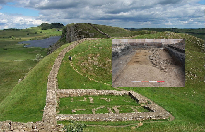
The remains of Milecastle 39 (coordinates 55° 0' 13.12" N, 2° 22' 32.74" W) on Hadrian's Wall; near Steel Rigg, looking east from a ridge along the Hadrian's Wall Path. Milecastle 39 is also known as Castle Nick. Credit: Adam Cuerden - Public Domain
The Pre-Construct Archaeology (PCA) has now also announced scientists conducting Durham excavations in the Ouseburn area of Newcastle have uncovered the remains of Turret 3a of Hadrian’s Wall!
"Turret 3a is one of the largest turrets uncovered and the only known confirmed turret east of Newcastle. Excitingly, our investigation has demonstrated that the potential for significant archaeological remains relating to Hadrian’s Wall can survive in the more built-up areas of urban Tyneside, with the discovery of the wall ditch and six berm obstacle pits as well as the remains of Turret 3a," the PCA informs in a press statement.
Turret 3a showing cippi pits. Credit: PCA
A desk-based assessment completed in support of the development had shown that the site was located across the line of Hadrian’s Wall and the wall ditch, and the survival of the ditch within site was established during limited archaeological trenching undertaken in 1928. However, where investigated, the wall was absent.
In 2015, an archaeological evaluation uncovered sandstone rubble, interpreted as the robbed out and disturbed remains of the rubble core of the wall, along with the defensive ditch crossing the site's northern edge. Two undated features were also recorded, one of which was a possible cippi pit forming part of the wall’s defensive system.
"Turret 3a, revealed by our latest phase of work, was located at the northeast end of the excavation area and the north wall of the turret/curtain wall of Hadrian’s Wall was exposed for a maximum length of around 12m, with foundations between 2.36m to 2.46m wide. No remains of a clay or flagged floor surface was identified within the internal area of the turret; any such evidence is likely to have been truncated by levelling or construction activity during the late 19th to early 20th century.
Finds recovered from the turret were sparse with only a single fragment of Roman tegula recovered from the foundations of the northern wall. At first this would appear to suggest that the turret roof was covered in tiles, however, where found, fragments of tegula are always in low quantities. Stone slates have also been found on other turrets along the Wall but again in low quantities. It has been suggested that wooden shingles and thatch may have been used (citing the pictorial representation on Trajan’s Column that shows towers with pyramidal thatched roofs).
The wall ditch. Credit: PCA
Six pits were noted within the berm (the area between the wall itself and the wall ditch). Locally, these cippi pits have been seen during excavations at a number of sites. Recent archaeological work has identified that the berm was sometimes occupied by patterns of pits, each presumably holding timber uprights. There are several types of defensive pits noted on Roman frontiers comprising entanglements (intertwined array of sharpened branches known as cippi or cervi/cervoli pits), entrapment (sharpened stakes covered with brushwood and leaves to act as traps known as lilia) and open pits (large pits designed to slow down attackers). The pits recorded here were too shallow and small to have functioned as open pits so they are most likely to have been cippi pits.
The wall ditch was exposed for a distance of around 9m and was around 8m wide by over 2m deep. The ditch deposits were sampled and are potentially highly environmentally significant, however a more detailed level of environmental analysis is required in order to ascertain the environmental potential of these deposits," the science team stated.
"The investigation at Crawhall Road has demonstrated that the potential for significant archaeological remains relating to Hadrian’s Wall can survive in the more built-up areas of urban Tyneside with the remains of the Turret 3a, the Wall Ditch and berm obstacle pits being encountered.
Turret 3a. Credit: PCA
The exact positioning of milecastles and turrets within the Newcastle to Wallsend section is unclear with the structures not appearing to follow the assumed spacing i.e., a milecastle at every Roman mile and two turrets spaced equidistantly between.
See also: More Archaeology News
Measurements from MC1 suggest that the turret should be located to the southwest of the site around Melbourne Street however its positioning on the top bank of the valley suggest that strategic positioning outweighed the original spacing scheme," Scott Vance, site director, said.
Written by Jan Bartek - AncientPages.com Staff Writer
