Drone Footage Reveals Ancient Mesopotamian City Lagash Was Made Of Marsh Islands
Jan Bartek - AncientPages.com - Impressive drone footage has revealed an ancient Mesopotamian city known as Lagash challenges long-held ideas about the origin and development of the world’s oldest urban centers in southern Iraq.
The collection of large-scale remote sensing data has "helped to rehydrate an ancient southern Mesopotamian city, tagging it as what amounted to a Venice of the Fertile Crescent. Identifying the watery nature of this early metropolis has important implications for how urban life flourished nearly 5,000 years ago between the Tigris and Euphrates rivers, where modern-day Iraq lies," Science News reports.
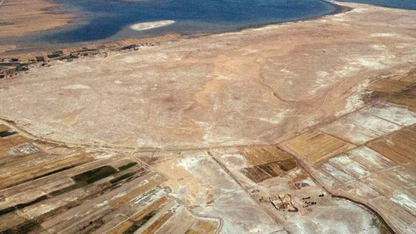
New remote-sensing studies at southern Iraq’s massive Tell al-Hiba site, shown here from the air, support an emerging view that an ancient city there largely consisted of four marsh islands. Credit: Lagash Archaeological Project
Anthropological archaeologist Emily Hammer of the University of Pennsylvania explained that remote-sensing data, mostly collected by a specially equipped drone, offers evidence a vast urban settlement called Lagash largely consisted of four marsh islands connected by waterways. These findings add crucial details to a growing consensus that southern Mesopotamian cities did not, as previously thought, expand outward from the temple and administrative districts into irrigated farmlands surrounded by a single city wall.
“There could have been multiple evolving ways for Lagash to be a city of marsh islands as human occupation and environmental change reshaped the landscape,” Hammer says.
"The standard model of third millennium BCE Mesopotamian cities presents them as nuclear, compact settlements set within an irrigated agricultural hinterland, expanding continuously from a monumental religious complex. This reconstruction holds enormous influence in the comparative global study of early urbanism. UAV photos and magnetic gradiometry data captured at Lagash (Tell al-Hiba) show dense architecture and related paleoenvironmental features over c. 300 ha, revealing a city that does not conform to the standard model.
Early Dynastic Lagash (2900–2350 BCE) was composed of spatially discrete sectors bounded by multiple surrounding walls and/or watercourses and separated by open spaces.
The evidence is suggestive of a marshy or watery local environment, and the city sectors may have originated as marsh islands. The discontinuous, walled nature of inhabited areas would have had social and logistical ramifications for city inhabitants. A number of contemporary sites are characterized by multiple archaeological mounds, suggesting that early southern Mesopotamian cities may have frequently been spatially multi-centric," the researchers write in their study.
Since Lagash had no geographical or ritual center, each city sector developed distinct economic practices on a single marsh island, one can compare the ancient Mesopotamian city to Venice in Italy, Hammer says.
This recent footage is of particular interest because previous analyses conducted by anthropological archaeologist Jennifer Pournelle of the University of South Carolina in Columbia indicated that Lagash and other southern Mesopotamian cities were built on raised mounds in marshes.
The study of detailed satellite images led archaeologist Elizabeth Stone of Stony Brook University to propose Lagash consisted of around 33 marsh islands, many of them quite small.
There is an important difference between satellite and drone images, Hammer points out.
Drone photos are necessary if we want a more detailed look at Lagash’s buried structures. The most recent drone footage of Lagash has delivered photos of remnants of buildings, walls, streets, waterways, and other city features buried near ground level.
This place if of great importance to archaeologists as well as historians.
Among the remains of the ancient city-state of Lagash located in Southern Mesopotamia are Sumerian literary hymns, prayers, and statues of its kings as well as under the rule of Gudea (ca. 2150–2125 BC) and his son Ur-Ningirsu (ca. 2125–2100 BC).
Statue of Gudea, the ruling prince, or king-priest, of the city of Lagash, carved in diorite. Credits: Louvre Museum, Paris - Public Domain
Based on several archaeological findings, scientists have also linked Urukagina (or Uruinimgina), an illegitimate and controversial ruler, to Lagash's ancient city. As discussed on AncientPages.com, "Urukagina’s s reign was in the time when Lagash's political and economic situation was unstable, after the downfall of his corrupt predecessor, Lugalanda. In Sumer, there was at the time political chaos and economic crisis, and wars only worsened the situation.
A corrupt civil bureaucracy nearly paralyzed the city of Lagash, and tax money went directly to the private pockets of the richest people.
The citizens of Lagash decided to overthrow the rulers and install the reformer king they trusted, namely, king Urukagina, who reformed the tax system, curtailed the corruption and terrible abuses of ordinary people by officials.
He canceled the taxes, fired all corrupted tax collectors. He also stopped at least temporarily the devastating influence of the powerful priests."
The recent drone photos give a comprehensive overview of how the inhabitants of Lagash lived, and the "drone data confirms the idea of settled islands interconnected by watercourses," says University of Chicago archaeologist Augusta McMahon, one of three co–field directors of ongoing excavations at the site.
As reported by Science News, "drone evidence of contrasting neighborhoods on different marsh islands, some looking planned and others more haphazardly arranged, reflect waves of immigration into Lagash between around 4,600 and 4,350 years ago, McMahon suggests. Excavated material indicates that new arrivals included residents of nearby and distant villages, mobile herders looking to settle down and slave laborers captured from neighboring city-states.
Dense clusters of residences and other buildings across much of Lagash suggest that tens of thousands of people lived there during its heyday, Hammer says. At that time, the city covered an estimated 4 to 6 square kilometers, nearly the area of Chicago.
Credit: E. Hammer/J. Anthropological Archaeology 2022
It’s unclear whether northern Mesopotamian cities from around 6,000 years ago, which were not located in marshes, contained separate city sectors (SN: 2/5/08). But Lagash and other southern Mesopotamian cities likely exploited water transport and trade among closely spaced settlements, enabling unprecedented growth, says archaeologist Guillermo Algaze of the University of California, San Diego.
See also: More Archaeology News
Lagash stands out as an early southern Mesopotamian city frozen in time, Hammer says. Nearby cities continued to be inhabited for a thousand years or more after Lagash’s abandonment, when the region had become less watery and sectors of longer-lasting cities had expanded and merged. At Lagash, “we have a rare opportunity to see what other ancient cities in the region looked like earlier in time,” Hammer says."
Written by Jan Bartek - AncientPages.com Staff Writer
Expand for references
