First-Ever Discovery Of Roman Road Network Spanning The South West UK Made By LIDAR
Jan Bartek - AncientPages.com - A Roman road network that spanned Devon and Cornwall and connected significant settlements with military forts across the two counties as well as wider Britannia has been discovered for the first time.
Archaeologists at the University of Exeter have used laser scans collected as part of the Environment Agency's National LiDAR Programme to identify new sections of road west of the previously understood boundary.
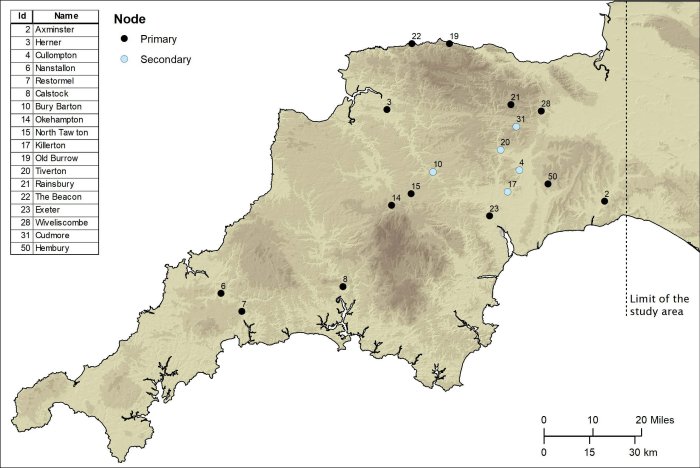
Primary and secondary nodes in the study area. Credit: University of Exeter
Using sophisticated geographical modeling techniques, which incorporate information around gradients and flood risk, the researchers have then been able to map out the full extent of the network and begin to understand the rationale for its existence.
Among the things it reveals is that far from Exeter being the main nerve center of the network, it was North Tawton that supported strategically vital connections with tidal estuaries north and south of Bodmin and Dartmoor.
These findings are explored in Remote Sensing and GIS Modeling of Roman Roads in South West Britain which has been published in the Journal of Computer Applications in Archaeology.
The research was led by Dr. Christopher Smart and Dr. João Fonte, specialists in landscape archaeology and the heritage of the Roman Empire, in Exeter's Department of Archaeology and History. Dr. César Parcero Oubiña, from the Institute of Heritage Sciences, Spanish National Research Council in Spain, specialist in geospatial technologies applied to archaeology, led the modeling of the Roman roads network.
"Despite more than 70 years of scholarship, published maps of the Roman road network in southern Britain have remained largely unchanged and all are consistent in showing that west of Exeter, Roman Isca, there was little solid evidence for a system of long-distance roads," Dr. Smart said.
"But the recent availability of seamless LiDAR coverage for Britain has provided the means to transform our understanding of the Roman road network that developed within the province, and nowhere more so than in the far south western counties, in the territory of the Dumnonii."
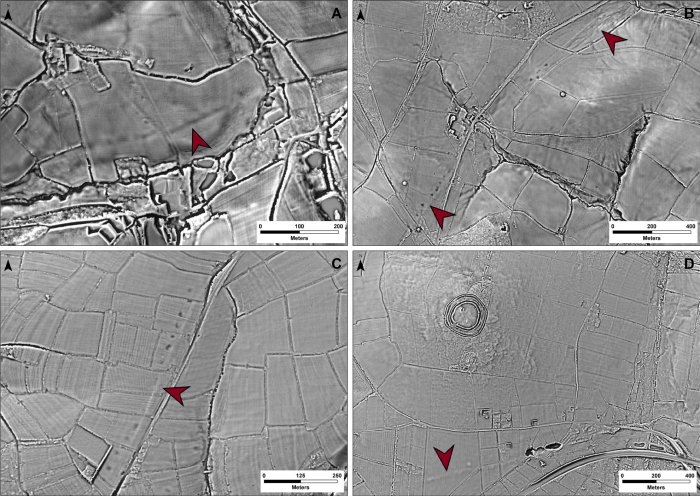
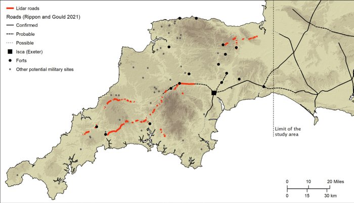
The National LiDAR (Light Detection and Ranging) Programme was conducted between 2016 and 2022 by the Environment Agency covering the whole of England, and the data was made available via the DEFRA Data Services Platform. It transformed the amount of terrain mapped of Devon and Cornwall, which had previously stood at just 11%. The Exeter team, working with public volunteers, studied the scans and together they were able to map around 100km of additional roads.
Examples of segments of Roman roads identified from the LiDAR-derived terrain models provided by Environment Agency's 'National LiDAR Programme'. Credit: The Environment Agency
Although this represented a significant advancement, the overall picture remained fragmented and patchy, with large portions of the map showing no evidence of Roman roads. So, the team developed a geographic information system predictive model, which could intelligently fill in the gaps as to the likely layout of the network.
Using an approach based upon Least Cost Paths—the optimal connections between two or more points—and other methods, such as focal mobility networks and transit corridors, the team began to plot primary and secondary 'nodes' across the two counties.
These included permanent military fortifications, including the known forts of Old Burrow and The Beacon at Martinhoe, as well as the settlements at Exeter and North Tawton. They then calculated the easiest routes between these points. And when the team returned to the LiDAR scans, they were able to identify a further 13km of Roman road within a short distance predicted by the model.
The final stage saw the researchers use focal mobility networks and transit corridors to extend the road network to areas that lay beyond the main Roman sites known in the region, suggesting some secondary or tertiary routes alternative to the single best optimal path in the process. This established a number of new 'terminal points', particularly in the far west of Cornwall and along its south coast.
"In terms of chronology, it is likely that the proposed network is an amalgam of pre-existing Prehistoric routeways, Roman military campaign roads or 'tactical roads' formally adopted into the provincial communications system, and of those constructed during peacetime in a wholly civilian context," says Dr. Fonte.
"This evolutionary model is supported by the fact that the network does not solely connect Roman forts and their hinterlands directly, which are often connected by branch roads, but instead appears to serve a broader purpose than required by military supply."
New sections of Roman roads in South West Britain identified through the 2022 National LiDAR Programme data, which covers the whole study area. Credit: University of Exeter
The research concludes that the main rationale for the network was to facilitate animal-drawn vehicles and circumvent those areas where flooding was possible. It could also influence, say the authors, future archaeological research in the region.
See also: More Archaeology News
"This network, identified by the scans and the GIS-enabled modeling, may serve to predict the location of settlements that are as yet unknown to us," adds Dr. Smart. "New archaeological evidence, including that proposed here for the existence of a wide-reaching Roman road network, urges for a reconsideration of the degree of capital investment in infrastructure and the development of a more complex settlement network hierarchy in the Roman South West Britain."
The study was published in the Journal of Computer Applications in Archaeology
Written by Jan Bartek - AncientPages.com Staff Writer

