Conny Waters - AncientPages.com - Researchers from the Higashi Nippon International University, Tohoku University, and the National Research Institute of Astronomy and Geophysics (NRIAG), Helwan, Egypt, undertook ground-penetrating radar (GPR) and electrical resistivity tomography (ERT) surveys at the Western Cemetery in Giza, Egypt.
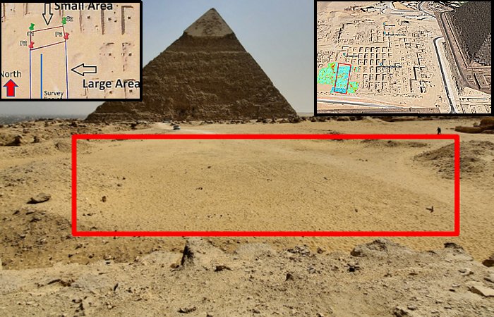
Survey area, looking south from mastaba G4000. The red rectangle shows the approximate location of the initial survey area. Image source: Archaeological Prospection
The team 's findings suggest the identification of an L-shaped structure measuring approximately 10 m by 15 m at a depth ranging from 0.5 to 2 m. This structure appears to be filled with homogeneous sand, indicating the presence of a void that was subsequently filled with sand after construction.
Furthermore, at the same location but at a greater depth, the ERT data revealed a highly resistive anomaly, which may be attributed to a highly resistive material such as sand or a void.
This anomaly extends to 3.5–10 m in depth and over a horizontal area of 10 m by 10 m.
Although the survey data do not conclusively identify the source of the observed anomaly, they may potentially indicate the presence of an extensive subsurface archaeological structure of significant magnitude.
Location of the survey area projected on Google Maps. The red rectangle shows the area of the initial survey. The colour figure shows the horizontal profile of GPR. View is to the north. The area has no visible structures. It is mostly flat ground with a compacted sand surface. There are small mounds in several places, where the sand contains rocky blocks. A straight road runs from the southeast to the northwest across the survey area. The road is of compacted sand and does not contain any construction material such as concrete. Image source: Archaeological Prospection
The Western Cemetery at Giza is a significant burial site for members of the royal family and high-ranking officials, and many excavations have been conducted in the area.
The majority of the mastabas are aligned in a systematic north-to-south orientation. Archaeological excavations have unearthed numerous mastabas dating from the 4th to the 6th dynasties, yielding a wealth of artifacts.
The Western Cemetery, spanning approximately 560 m from east to west and 370 m from north to south, is densely populated with mastabas of varying dimensions.
However, an area in the central region with no above-ground structures exists.
This area measures approximately 80 m from east to west and 110 m from north to south. It is bounded on the eastern side by the G4200 cemetery, on the western side by the G6000 cemetery, on the southern side by an enclosure wall, and on the northern side by the G4000 mastaba of Hemuon.
No significant excavation results have been previously reported for this area.
In recent years, Dr. Zahi Hawass, who has been conducting extensive excavations throughout the Giza Pyramid area, has made notable discoveries in the Western Cemetery. These include the basalt seated statue of the dwarf Perniankh and the limestone statue of Kapunisut Kai, both invaluable artifacts.
Cemetery G 4000: G 4651, Kapunisut Kai, chapel. Digital Giza at Harvard University.
While there are no significant remains above ground in this area, the potential for discovery below the ground is vast. No underground investigations have previously been carried out, leaving a world of history and secrets waiting to be unearthed.
The necropolis was designated exclusively for the King Khufu's royal family and esteemed officials, buried in their mastabas, which are typical ancient underground graves. A mastaba is a type of tomb with a flat roof and rectangular structure on the ground surface, constructed out of limestone or mudbricks. It has a vertical shaft connected to a subsurface chamber.
Most such sites are buried under overburdened sand, and it is not easy to locate their exact positions from the surface. Under such conditions, their positions can be identified by the shallow geophysical exploration methods.
It is said to be important to explore below the surface of this blank area, using GPR and ERT, in order to investigate the entire Western Cemetery.
The results of our GPR and ERT survey suggest the possibility of archaeological remains.
It is important that they be promptly excavated to establish their purpose.
Paper - GPR and ERT Exploration in the Western Cemetery in Giza, Egypt".
Written by Conny Waters - AncientPages.com Staff Writer
