


Jan Bartek - AncientPages.com - Cahokia Mounds is an enigmatic ancient Native American site located east of St. Louis. It comprises over 100 earthen mounds used for burial and ceremonial purposes. The archaeological finds, such as pottery fragments, shell pieces, and etched symbols on copper, wood, and stone, provide insights into the prehistoric people who constructed this site, often called the "Mississippian" people, although their names remain unknown.

Image courtesy of Cahokia Mounds Historic State Site. Painting by William R. Iseminger.
Cahokia was undoubtedly one of the most advanced civilizations in North America. Still, its puzzling history raises many unanswered questions, particularly regarding its downfall, which has been a subject of ongoing debate. At its peak, this Pre-Columbian metropolis in present-day southern Illinois was home to a staggering population of 40,000 across six square miles, earning it the moniker "City of the Sun."
However, around 1200 A.D., the inhabitants of Cahokia mysteriously abandoned their houses for unexplained reasons. When Christopher Columbus and the Spanish conquistadors arrived, they found no traces of the former inhabitants, leaving the fate of this once-thriving civilization shrouded in mystery.
Scientists from St. Louis University and the National Geospatial-Intelligence Agency are embarking on an ambitious project to create the most comprehensive and authoritative 3D map of Cahokia Mounds. This endeavor aims to provide a detailed and accurate representation of the famed prehistoric site, which will serve as a valuable resource for future studies and research.
To achieve this goal, the researchers employ cutting-edge technologies, including drones and Light Detection and Ranging (LiDAR) technology. LiDAR, a remote sensing method that uses laser light to measure distances, will enable the team to identify and map previously undocumented portions of the 2,200-acre National Historical Landmark with unprecedented precision.
Integrating cutting-edge technologies like LiDAR enhances our understanding of historical sites and landscapes, enabling researchers to uncover new information without compromising the integrity of these invaluable resources.
By combining the data gathered from these advanced techniques, the researchers will be able to generate a highly detailed and accurate 3D model of Cahokia Mounds. This comprehensive map will enhance our understanding of the site's layout and features and provide a valuable baseline for future archaeological investigations and preservation efforts.
The use of advanced technologies like LiDAR (Light Detection and Ranging) is revolutionizing archaeology. Last autumn, researchers employed UAVs (Unmanned Aerial Vehicles) and other tools to scan approximately 1.5 square kilometers of the Cahokia Mounds site. This non-invasive approach allowed them to gather valuable data without disturbing the site itself.
LiDAR's ability to capture minute elevation changes, even beneath vegetation or other obstructions, makes it an invaluable tool for archaeology, agriculture, forestry, and other domains. It serves as a cornerstone for many types of research at the Talespire Geospatial Institute (TGI).
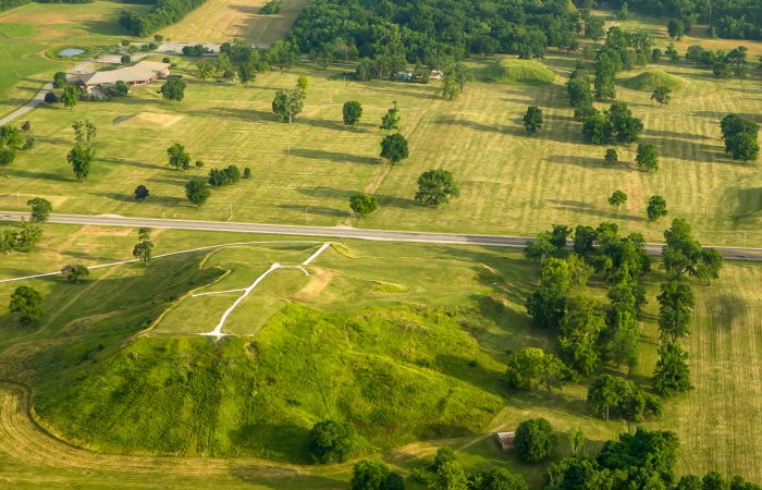
Aerial view of Cahokia Mounds. Credit: Adobe Stock - Kent
Justin Vilbig, an SLU PhD candidate in Dr. Vasit Sagan's remote sensing lab and a TGI data scientist, leads the study.
One notable discovery facilitated by LiDAR data was an elusive causeway that had been identified by archaeologists in the past but was subsequently obscured by brush and forest growth. The collected data will be processed and refined to provide further insights into this intriguing feature.
“Part of our hope with this UAV collections is that we’ll get much better resolution for that causeway identification and context,” Vilbig said.
Vilbig mentioned that the team is actively searching for the location and extent of "borrow pits," which are slight depressions in the ground that may indicate where ancient builders obtained earth to construct mounds.

See also: More Archaeology News
“My hope is that we are able to claw back some of that story and tell that story with more richness and more detail,” Vilbig said. “If we have technology that allows us to answer questions without destroying that should always be our first line of investigation.”
“Cahokia was the original St. Louis,” Vilbig added.
The United Nations has labeled Cahokia as one of 1,119 “World Heritage Sites” around the globe. These sites are legally safeguarded due to their cultural, historical, or scientific significance. This recognition highlights the importance of preserving and protecting sites that hold invaluable insights into our shared human heritage and contribute to our understanding of diverse civilizations and their legacies.
Written by Jan Bartek - AncientPages.com Staff Writer

