Huge Folklore Map With Supernatural Beings And Mythical Monsters Created – Available For Free Online
Jan Bartek - AncientPages.com - A dedicated research team deserves recognition for their incredible work in creating an extensive map illustrating the spatial distribution of supernatural beings along the Polish-German borderland.
Credit: Journal of Maps
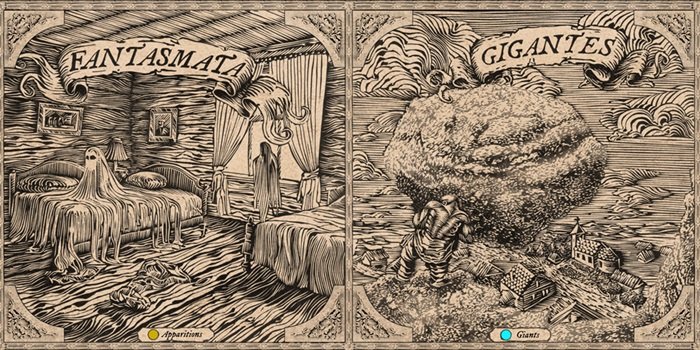
This impressive project captures various phenomena, including devils, spirits, wild hunters, gnomes, will-o'-the-wisps, giants, dragons, mermaids, ghosts, werewolves, apparitions, and nightmares. Drawing from 19th and 20th-century folkloric sources compiled into a geospatial database, this map is a remarkable achievement that enriches our understanding of cultural heritage and folklore.
This stylized map, developed at a scale of 1:720,000 as part of a research project funded by the National Science Center, is now freely available online through a scientific publication in the Journal of Maps.
This resource allows residents of Pomerania, folklore enthusiasts, fantasy fans, map aficionados, art lovers, ethnographers, and cartographers to explore historical sites linked to nightmares and supernatural beings like ghosts or water spirits from 150 years ago. The creation of this unique map required an interdisciplinary team comprising an ethnographer, cartographer, historian of cartography, graphic artist, writer, and computer scientist.
Ethnologist Dr. Robert Piotrowski, a member of the Interdisciplinary Anthropocene Research Team at the Institute of Geography and Spatial Organization of the Polish Academy of Sciences, conducted an analysis of materials from German and Polish folklorists such as Otto Knoop, Karol Bartsch, Oskar Kolberg, and Stefan Ramult.
These folklorists documented stories from Pomerania's inhabitants around the late 19th and early 20th centuries. Dr. Piotrowski compiled 1,200 examples of beliefs and ideas related to the supernatural world through this research. A map was created using data from 600 locations where local communities linked specific landscape features—such as erratic boulders, moraine hills, or peat bogs—to religious legends.
Credit: Journal of Maps
"We were mainly interested in local stories about uncanny events associated with specific places. For example, religious legends imagining witches meeting on a particular mountain, a boulder once thrown by a giant, the devil building a dam on a lake, or will-o'-the-wisp appearing in a swamp. The combination of natural and religious contexts allowed us to recreate how the inhabitants of the studied regions valued the landscape," explained Dr. Piotrowski in a press release.
At the start of the 20th century, beliefs about the supernatural were instrumental in explaining natural phenomena and geological origins through cultural perspectives. These beliefs helped form a coherent view of reality that was both daunting and reassuring due to its structured nature. Dr. Wlodzimierz Juskiewicz, a cartographer from IGiPZ PAN, highlights that maps are invaluable tools for understanding our world. He set out to create a fully cartometric map using contemporary knowledge but aimed to present it in an engaging format beyond traditional standards. His objective was to captivate audiences with an unconventional design showcasing intriguing data.
Credit: Journal of Maps
Dr. Juskiewicz determined that Renaissance map aesthetics would best capture the era's atmosphere and relate well to depicted demonic figures. During this period in Italy, maps were esteemed as art forms and celebrated for their artistic refinement. Drawing inspiration from this tradition, he sought to merge scientific accuracy with artistic flair, crafting a map that conveys information and offers visual delight.
Renaissance maps are famous for their depictions of monsters. "In the past, these monsters filled blank spaces—such as water or unknown areas on maps," explained Dr. Dariusz Brykala, a geographer specializing in the history of cartography from IGiPZ PAN. He added that monsters appeared in scientific publications as late as the 18th century, for instance, in the first version of Carl Linnaeus's taxonomy of the animal kingdom.
The map it available online for free as part of a scientific publication in the Journal of Maps .
Written by Jan Bartek - AncientPages.com Staff Writer


