Ingenious Paleolithic 3D Map Was Discovered In The Ségognole 3 Cave South Of Paris, France
Conny Waters - AncientPages.com - Probably the world's oldest three-dimensional map has been discovered at the Ségognole 3 rock shelter, located within the Fontainebleau sandstones to the south of Paris.
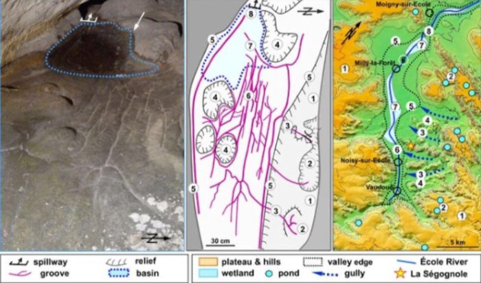
View of the three-dimensional map on the Ségognole 3 cave floor. Image credit: Dr Médard Thiry
This ancient site has been under study for more than 40 years and is renowned for its artistic engravings, particularly those depicting two horses.
The Ségognole 3 rock shelter, recognized since the 1980s for its Late Palaeolithic artistic engravings depicting two horses flanking a female pubic figure, has recently been discovered to also include a miniature depiction of the surrounding landscape. This new finding adds significant depth to our understanding of the site's historical and cultural context.
Dr. Médard Thiry from the Mines Paris - PSL Centre of Geosciences, was involved in his earlier research, conducted after his initial visit to the site in 2017, compellingly demonstrated that Palaeolithic people intentionally shaped the sandstone to resemble the female form.
This meticulous work also created fractures that allowed water to infiltrate and nourish an outflow at the base of what is known as the pelvic triangle. Such findings offer a fascinating glimpse into their sophisticated understanding and manipulation of natural resources, making a strong case for further exploration and study of these ancient techniques.
View of the three-dimensional map on the Ségognole 3 cave floor. Image credit: Dr Médard Thiry
Milnes and Thiry's recent study, as published in the Oxford Journal of Archaeology, has identified the presence of three-dimensional modeling through a meticulous examination of fine-scale geomorphological features.
Recent research indicates that a section of the floor in the sandstone shelter, shaped and modified by Palaeolithic people approximately 13,000 years ago, was designed to mirror the region's natural water flows and geomorphological characteristics.
Dr. Anthony Milnes affiliated with the University of Adelaide's School of Physics, Chemistry and Earth Sciences, who was also involved in the research explains that the depiction in question does not constitute a map in the contemporary sense, characterized by distances, directions, and travel times. Instead, it represents a three-dimensional model illustrating the dynamics of a landscape. This includes the flow of runoff from highlands into streams and rivers, the merging of valleys, and the subsequent formation of lakes and swamps downstream.
For Palaeolithic peoples, understanding the direction of water flows and identifying landscape features were likely more crucial than contemporary concepts such as distance and time. These elements played a significant role in their navigation and survival strategies, highlighting the importance of environmental awareness in their daily lives.
Mapping of the cave floor with École River valley. Image credit: Dr Médard Thiry
The findings of our study indicate that human alterations to the hydraulic behavior in and around the shelter extended to modeling natural water flows within the surrounding landscape. These exceptional results distinctly highlight the cognitive abilities, imaginative prowess, and engineering skills possessed by our distant ancestors.
Due to his comprehensive research on the origin of Fontainebleau sandstone, Dr. Thiry identified several fine-scale morphological features that appear unlikely to have formed naturally. This evidence suggests that these features were modified by early humans, providing valuable insights into human history and prehistoric activities.
"Our research showed that Palaeolithic humans sculpted the sandstone to promote specific flow paths for infiltrating and directing rainwater which is something that had never been recognised by archaeologists," Thiry says.
"The fittings probably have a much deeper, mythical meaning, related to water. The two hydraulic installations - that of the sexual figuration and that of the miniature landscape - are two to three metres from each other and are sure to relay a profound meaning of conception of life and nature, which will never be accessible to us."
“This completely new discovery offers a better understanding and insight into the capacity of these early humans,” Thiry says.
Prior to this discovery, the oldest known three-dimensional map was believed to be a sizable portable rock slab created by Bronze Age individuals approximately 3,000 years ago. This ancient map illustrated a local river network and earth mounds, embodying an early concept of modern maps used for navigation purposes.
"We believe the most productive research outcomes are found at the boundaries between disciplines," Dr Milnes says, adding that collaborating across disciplines - such as archaeology, geology, and geomorphology - is no doubt vital in science.
Dr. Thiry emphasizes the significance of re-evaluating field studies and conducting regular site visits. It is evident from our ongoing project that insights and interpretations do not manifest instantaneously; rather, they develop through new observations and interdisciplinary discussions.
Written by Conny Waters - AncientPages.com Staff Writer


