Baltinglass Hills: Prehistoric Irish Monuments May Have Served As Pathways For The Deceased – New Evidence
Conny Waters - AncientPages.com - Using advanced lidar technology, researchers have uncovered hundreds of monuments within the renowned prehistoric landscape of Baltinglass, Ireland.
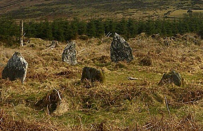
The Late Bronze Age stone circle at Boleycarrigeen, with Keadeen cursus near the summit of the mountain in the background. Credit: J. O’Driscoll
This significant find sheds invaluable light on the ritual practices and activities of the ancient farming communities that once inhabited this region.
Baltinglass - located on the River Slaney near the border with County Carlow and County Kildare - is famous for its Early Neolithic and Late Bronze Age monuments.
As evidence for occupation and activity during these periods was almost non-existent in the area, it was postulated that it might have been abandoned for approximately two millennia.
"While we know that this was an incredibly important, and in many ways, unique landscape in Early Neolithic Ireland, there was very little evidence to suggest that this area continued to be as important again until the Late Bronze Age," said author Dr. James O'Driscoll from the University of Aberdeen.
"Did the early farming communities of Baltinglass abandon this landscape after a few hundred years of use?"
Dr. O'Driscoll created highly detailed three-dimensional models of the Baltinglass landscape using lidar technology to answer this question.
Lidar map (enlarged area) of the Sruhaun cursus in context, highlighting nearby burial monuments and hillforts. Credit: J. O’Driscoll
The vast majority of the monuments have been subjected to extensive deterioration over the course of millennia due to continuous agricultural activities.
However, the deployment of lidar technology has enabled the detection of minute topographical traces, revealing the existence of hundreds of previously undiscovered monuments within the area.
Undoubtedly, the most significant part of our research is the discovery of five cursus monuments. These long, narrow earthwork enclosures, well-known from the Middle Neolithic in Britain, have not been well-studied in Ireland, making our findings all the more important.
This discovery of the largest cursus clusters found in Britain and Ireland suggests that Baltinglass region continued to be intensively settled between the Early Neolithic and late Bronze Age.
The latest LIDAR survey has significantly contributed to a better understanding of the archaeological legacy present in this region of west Wicklow, according to Deirdre Burns, Heritage Officer at Wicklow County Council.
The cursus monuments are aligned with burial monuments within the landscape and the rising and setting sun during significant solar events such as the solstice.
This alignment suggests a deliberate and purposeful arrangement, which means these ancient people - responsible for the construction of these monuments - had the intricate astronomical knowledge.
"This may have symbolized the ascent of the dead into the heavens and their perceived rebirth, with the cursus physically setting out the final route of the dead, where they left the land of the living and joined the ancestors beyond the visible horizon," suggests Dr. O'Driscoll.
These archaeological findings shed light on prehistoric life in Ireland and contribute to the preservation of these invaluable monuments for the future.
The recent findings undoubtedly provide invaluable insights into the lives of the ancient agrarian communities that inhabited Baltinglass approximately 6,000 years ago. We can learn much more about these people’s religious and ceremonial rituals, as well as the reverence and remembrance of the dead, according to the researcher.
Written by Conny Waters - AncientPages.com Staff Writer

