Stunning Madaba Map: Oldest Known Mosaic Built Of Two Million Stone Cubes
A. Sutherland - AncientPages.com - The map of Madaba is the oldest known and existing geographic floor mosaic map of the Holy Lands in art history.
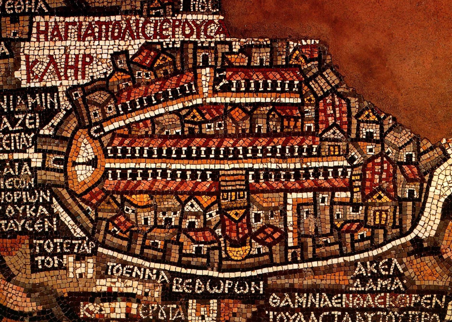 The fragment that depicts Jerusalem. Walls are visible around the big cities, including Jerusalem, Jericho, and Ashdod. Jerusalem is the focus of the map. The Madaba Map Centenary, 1897-1997 - Unknown author - Public Domain
This beautiful and colorful work of ancient artists (or perhaps cartographers) who had both skills and biblical knowledge shows very accurate locations of the area, from Tyre in the north to the Egyptian Delta in the south, with all mountains, rivers, and the major cities.
The map that was created between 542 and 570 covers the floor of the Basilica of St. George in the city of Madaba ("the city of mosaics") in Jordan, about 15 miles southeast of the northern part of the Dead Sea.
The history of Madaba (mentioned in the Bible and on the Mesha Stele) goes back thousands of years. The first settlements in the area formed there in the 4th millennium BC. At the time of the Exodus and conquest, 1406 BC, Madaba, and Mt. Nebo were part of the territory of Moab. (Isa 15:2; Num 36:1; Deut 32:49.)
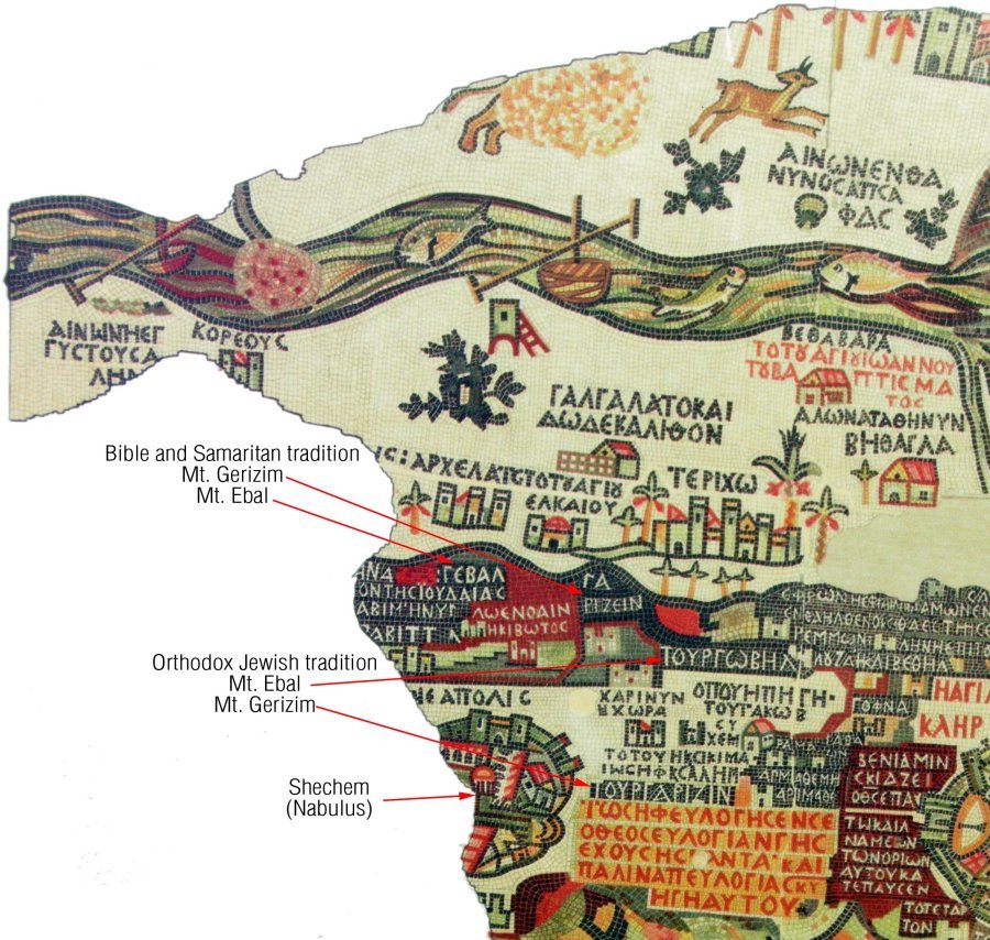 Madaba Map of Biblical Lands. Image credit: Bible ca.
Taken by the Amorite king Sihon, which happened shortly before Joshua's conquest of Canaan, the Israelites passed through, took the city of Madaba, and conquered Sihon.
According to 1 Maccabees 9:32-42, Madaba was inhabited by a Nabataean tribe, the sons of Jambri, in the 2nd century BC.
Madaba had a long and turbulent history of being constantly captured by one enemy and passed back and forth from one conqueror to another.
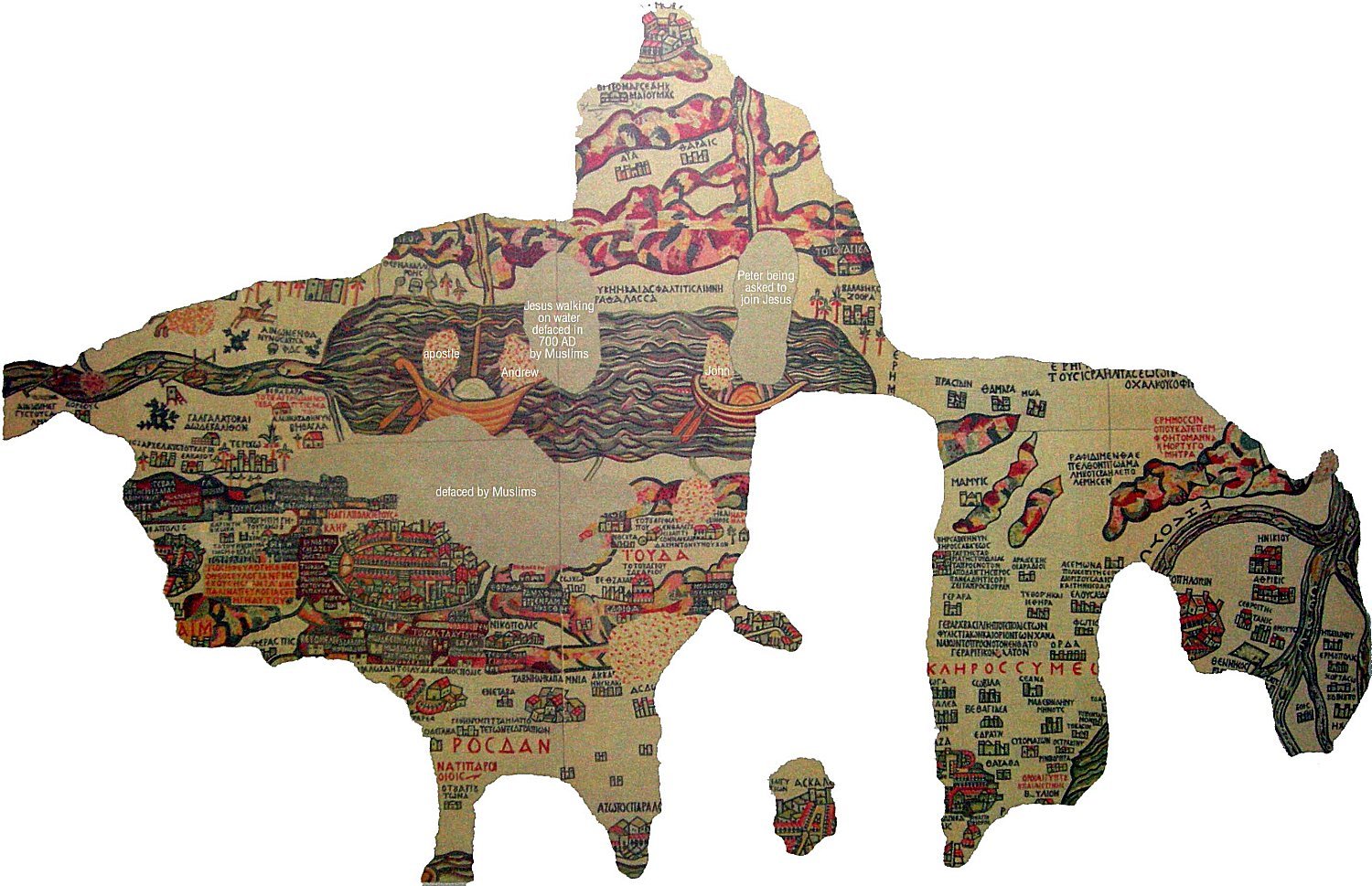 Madaba Map is considered by some scholars to be the best topographic representation ever done before modern cartography. Image credit: bible.ca
The map was initially created during the reign of emperor Justinian, 527-565 AD. It was formed of 2 million colored cubes and measured about 51 feet x 19.5 feet (15.5 m x 6 m).
The present remains of the map are composed of 750,000 cubes measuring 34.5 feet x 16.5 feet (10.5 m x 5 m and 150 Greek inscriptions in various sizes.
The most detailed element of the topographic depiction is Jerusalem, located at the center of the map. The anonymous artist accurately portrayed the old buildings of Jerusalem's Old Town, its gates, and some facilities, such as the Basilica of the Holy Sepulcher, Gethsemane, and the Citadel of David.
 Madaba Mosaic Map on the floor of the Basilica of St. George in the "city of of mosaics” in Jordan. Image credit: Visitpalestine.ps
Archaeological excavations conducted in 2010 further substantiated its accuracy with the discovery of a road depicted on the map that runs through the center of Jerusalem.
There are also clearly depictions of the Dead Sea, the bridges connecting the banks of the Jordan, river fish, and lions hunting gazelles on the Moab steppes, as well as cities, such as the Jericho palms and sacred places of Christians such as Bethlehem.
The mosaic was rediscovered in 1884 during the construction of a new Greek Orthodox church. In 1965-1966, the map was rediscovered and described by German archaeologists. All objects shown on the map are represented in Greek.
The unknown artists probably made the map for the Christian community of Madaba, which was the bishop's seat at that time. In 614, Madaba was conquered by the Sasanian Empire. In the eighth century, the ruling Muslim Umayyad Caliphate had some figural motifs removed from the mosaic.
Patriarch Nicodemus I of Jerusalem was informed about the incident, but no research was carried out until 1896 AD.
Unfortunately, large portions of the Madaba Map were damaged by fires and moisture effects that destroyed the art's quality. In 1965, major restoration works were undertaken to restore the remaining parts of the mosaic.
Written by – A. Sutherland - AncientPages.com Senior Staff Writer
Updated on September 29, 2022
Copyright © AncientPages.com All rights reserved. This material may not be published, broadcast, rewritten or redistributed in whole or part without the express written permission of AncientPages.com
Expand for referencesReferences:
Aa.Vv. The Mediterranean Medina: International Seminar
More From Ancient Pages
-
 8,000-Year-Old Petroglyphs Discovered In Oldest Impact Crater In South Africa
Archaeology | Jun 21, 2019
 -
 Vatican Secrets – Extraterrestrial Life And Genetically Engineering Of Humans By Advanced Alien Species
Featured Stories | Oct 6, 2018
 -
 Sunduki – ‘Home Of The Gods’ – One Of The World’s Oldest Astronomical Observatories
Civilizations | Oct 4, 2015
 -
 120,000-Year-Old Human Footprints Discovered In Saudi Arabia
Archaeology | Sep 18, 2020
 -
 12,000-Year-Old Rock Art In North America – Dating Petroglyphs In The American West
Archaeology | Mar 4, 2022
 -
 Ginnungagap From Which The World, Gods, Humanity And All Life Emerged In Norse Beliefs
Myths & Legends | Dec 11, 2024
 -
 Why Did Neolithic Make Us Taller And More Intelligent But More Prune To Heart Disease?
Archaeology | Apr 8, 2022
 -
 Late Pleistocene Human Colonization – What Makes Our Species Unique Compared To Other Hominins?
Archaeology | Apr 29, 2020
 -
 DNA Shows First Scandinavians Followed Two Distinct Migration Routes
Archaeology | Jan 11, 2018
 -
 Magical Dinas Emrys – Battle Of The Dragons And Merlin’s Hidden Treasure
Featured Stories | May 21, 2019
 -
 On This Day In History: Battle Of Vincennes, Indiana – On Feb 24-25, 1779
News | Feb 24, 2017
 -
 Secrets Of The Jungle And Hidden Ancient Treasures Of The Serpent People
Featured Stories | Feb 29, 2020
 -
 Karahunge – ‘Speaking Stones’ With Secrets – Remarkable Prehistoric Structures Of Armenia
Places | Jun 4, 2020
 -
 Restoration Of Valuable 4th Century Silk Tunics Attributed To St. Ambrose Takes Place In Milan
Artifacts | Apr 12, 2017
 -
 Early Humans Risked Life -Threatening Flintknapping Injuries – Long-Lasting Tradition
Archaeology | May 26, 2023
 -
 Unexplained Mysteries Of The Superstition Mountains – A Gateway To Other Worlds?
Featured Stories | Dec 15, 2020
 -
 Discovered 3,700-Year-Old Clay Tablet Shows Babylonians Used Geometry Long Before Pythagoras
Archaeology | Aug 4, 2021
 -
 Scientists Say Dinosaurs Could Be The Reason Humans Can’t Live For 200 Years
Featured Stories | Jan 8, 2024
 -
 Origin Of Elongated Skulls In Early Medieval Germany – New DNA Study
Archaeology | Mar 13, 2018
 -
 Amaterasu: Shinto Goddess Of The Sun And Priestess-Queen Sister To Controversial Susanoo God Of Storms
Featured Stories | Jan 25, 2019
